 |
| The
Samoan Chain: A Shallow Lithospheric Fracture
System |
|
|
|
|
Abstract
Samoan volcanism has occurred mainly along a
series of lithospheric fractures that are produced
by deformation of the underlying Pacific plate near
the Tonga Trench. Most are delineated by aligned volcanic
centers 10-50 km apart. The centers coalesce into
volcanic ridges that form serially at the eastern
end of the chain as the approaching Pacific lithosphere
first begins to experience shear stresses near the
westward curving corner of the trench. One fracture,
the Samoan post-erosional volcanic rift system, is
superimposed on at least three of these, has small
vents spaced only 1-6 km (average 2 km) apart, has
erupted only nephelinite-series mafic lavas, and has
been active along a length of > 200 km since the
Quaternary. It results from lateral plate bending
toward the transform portion of the trench. Although
lava compositions systematically are greatly enriched
in the radiogenic isotopes of Sr, Nd, and Pb, each
lineament is geochemically distinctive. The lavas
thus appear to be tapped from a laterally widespread
layer of heterogeneously enriched mantle at the base
of the lithosphere rather than a geochemically coherent
mantle plume.
|
|
Introduction
The following
is a shortened version a manuscript by the same title
currently in review. First, I consider bathymetry, island
geology, and lava geochemistry and present a general
description of the patterns and style of volcanism in
the Samoan chain. Then I apply simple principles of
fracture mechanics to explain that Samoan volcanism
results from tapping of a shallow enriched asthenospheric
layer through fractures induced by deformation of the
Pacific plate near the Tonga Trench (see also Cracks
& Stress page). |
|
Bathymetry
The Samoan
linear volcanic chain lies near a portion of the Tonga
Trench (Figure 1a). From west to east, the principal
islands are Savai`ii, Upolu, Tutuila, Ofu-Olosega and
Ta`u (Figure 1b). The Samoan chain has been attributed
either to volcanism along a seafloor fracture (Dana,
1849; Kear & Wood, 1959; Hawkins &
Natland, 1975; Natland, 1980), or to a
mantle plume (Farley et al., 1992; Hart
et al., 2000; Courtillot et al., 2003).
The chain was built in two principal stages:
1) A sequence
of shield and associated satellite volcanoes (Stearns,
1944), each consisting mainly of alkalic olivine basalt
and its differentiates, that are progressively younger
toward the east (Natland, 1980; Natland
& Turner, 1985) culminating in the active Vailulu`u
(Hart et al., 2000); and
2) A post-erosional
succession of nephelinite-series lavas that erupted
in substantial volume chiefly from hundreds of cones
arrayed along a single rift system trending at about
285° across the Western Samoan islands of Savai`i
and Upolu, and reaching underwater from there to
Tutuila (Stearns,
1944; Kear & Wood, 1959). |
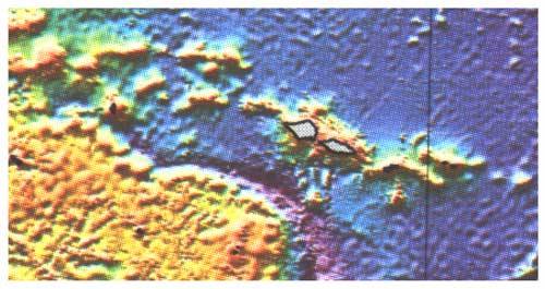
Figure 1a Distribution of volcanic
ridges of the Samoan linear volcanic chain north of
the western-trending, transform portion of the Tonga
Trench. Bathymetry of the Samoan region shown as shaded
relief illuminated from the north. From Smith &
Sandwell (1996). Light shading: shallow; dark shading:
deep. Islands are outlined with bold lines.
|
The
eastward progression of shield volcanoes is
a continuation of that established for volcanic
portions of submerged atolls to the west as
far as Combe Bank (Figure 1c), which is dated
at 14.1 Ma (Duncan, 1985). |
| An
isolated volcano south of Upolu, Machias Seamount,
dated radiometrically at 0.97 Ma (Hawkins
& Natland, 1975), sits precisely at
the curving corner of the trench (Figure 1b).
Subaerial materials were dredged near its summit,
which now is nearly 1 km deep, having subsided
that far in < 1 Myr. Between Machias and
Tutuila, sediments of the deformed Samoan apron
(Figure 1c) are downfaulted toward the trench
(Lonsdale, 1975). These are consequences
of the very complex subduction geometry around
the curving corner of the Tonga Trench. Where
the direction of plate motion is directly orthogonal
to the trench, the Pacific Plate is subducted
in a normal fashion (Figure 1c), and is traceable
to depths of about 700 km beneath the Tongan
arc and Lau Basin (Sykes et al., 1969;
Barazangi & Isacks, 1971). But
because the northern part of the trench veers
to the west, the trench itself becomes a transform
boundary, and the Pacific Plate there bends
laterally toward it. Beneath the northern Lau
Basin, the plate tears apart (Natland,
1980; Millen & Hamburger, 1998).
|
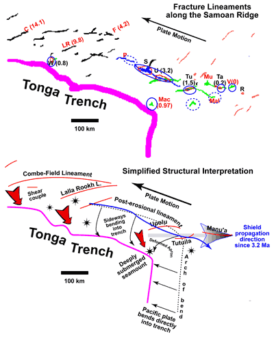
Figures 1b & c
b) (Top panel). Crest lines
of volcanic ridges in the Samoan region, taken
from Figure 1a. Radiometric ages are given in
parentheses, from Duncan (1985) and Natland
& Turner (1985). Circled locales have had
Quaternary-Historic volcanism. Islands and banks
are C = Combe Bank; F = Field Bank; LR = Lalla
Rookh Bank; W = Wallis Islands; P = Pasco Bank;
S = Savai`i Island; U = Upolu Island; T = Tutuila
Island; Ta = Ta`u Island; Mac = Machias Seamount;
MU = Muli Seamount; Mal = Malumalu Seamount;
V = Vailulu`u; R = Rose Islet. Rose is an older
volcanic feature not related to Samoan volcanism.
c) (Bottom panel). Simplified structural interpretation
showing trends of Samoan fracture lineaments
in relation to the vector of plate motion and
the transition from straightforward subduction
along the northerly trending portion of the
Tonga Trench, to lateral plate bending and likely
shear coupling on the Pacific Plate along the
westerly trending transform portion of the Trench.
Isolated volcanoes are shown by stars. |
Bathymetry derived from
satellite altimetry (Figure 1a) shows that
the several seamount ridges of the Samoan
chain are 100-250 km long (see scale bar in
Figure 1b), but many can clearly be linked
end to end as longer curving lineaments that
are broken by short gaps. Some of the curving
lineaments approach other, and their general
concavity is toward the Trench (Figure 1c).
The longest curving lineament extends from
Combe Bank to Field Bank. Two shorter lineaments,
one including Lalla Rookh Bank, are both closer
and more strongly inclined to the transform
portion of the Tonga trench. At the eastern
end of the chain, separate lineaments can
be distinguished for Upolu, Tutuila and the
Manu`a Group. Tutuila also curves toward the
trench.
The post-erosional rift
zone is parallel to the transform portion
of the trench. It has possible submarine extensions
toward Pasco Bank on the west and Malumalu
Seamount to the east, a distance of more than
500 km.
|
|
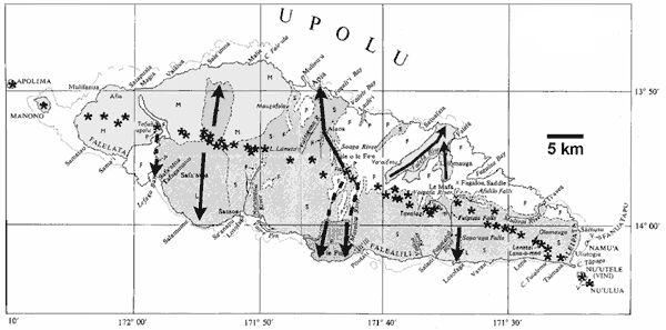
Figure 2 Summary geologic map of the island of Upolu,
modified from Kear & Wood (1959). The overall
trend of the island is 290°, parallel to that
portion of the post-erosional volcanic rift system
that spans the length of the island. Quaternary and
younger post-erosional lava flows are shaded, with
formation names of Kear & Wood (1959) given by
letters S = Salani volcanics; M = Mulifanua volcanics;
L = Lefaga volcanics; P = just prehistoric Puapua
volcanics. Lavas of the older Fagaloa shield volcano
(F) are not shaded. Asterisks give locations of the
line of post-erosional cones that delineates the post-erosional
rift on this island. Arrows show post-erosional flow
directions, each one beginning near the vent from
which the lava flows were emitted.
|
Patterns of Samoan Volcanism
Stearns
(1944) attempted to assign his four stages of Hawaiian
volcanism (Stearns, 1940) to Samoa. However,
the two chains differ in important respects. Thus
Stearns (1944) mapped four shield centers,
two with calderas, along the 35-km length of Tutuila.
A fifth center, the dike-ridden Masefau complex, is
overlain unconformably by younger lavas. The length
of the island is about half that of Kilauea's eastern
rift on Hawaii, and less than the length of some individual
lava flows on Kilauea or Mauna Loa. Centers of shield
volcanism on Tutuila thus are greatly compressed physically
compared with Hawaii, and they are strongly aligned.
The pattern
of closely spaced and aligned centers continues along
the Manu`a lineament, northeast of Tutuila. West to
east, the lineament comprises four volcanic centers.
Muli seamount is 55 km west of two emergent volcanoes
at Ofu-Olosega and Ta`u Islands (Stice & McCoy,
1968), which are 23 km apart. The active, shallow,
submarine volcano, Vailulu`u, is 50 km east of Ta`u..
Ofu-Olosega and Ta`u have coalesced into a single
structure at shallow depth, but still have separate
summits. Muli and Vailulu`u are linked to the central,
larger pair of volcanoes only by deep swales. West
of Tutuila, only one other similar volcanic center
has been mapped, the Fagaloa shield volcano of Upolu
(Kear & Wood, 1959; Natland &
Turner, 1985).
Post-erosional
volcanism is quite different. Hundreds of small volcanic
cones mark the trace of the Samoan post-erosional
rift zone across the islands of Savai`i and Upolu.
Most of the rift is only a few km wide, but it is
nearly 200 km long. To the east, it extends under
water to Tutuila (Natland, 1980). The principal
feature of these vents and of all post-erosional eruptions
is that the lava did not originate from a central
conduit system, nor did it erupt along any secondary
rift system supplied from a central conduit, like
the Kilauea eastern or southwest rifts (e.g., Fiske
& Jackson, 1972). Instead, individual eruptions
issued from single vents and in scattered fashion
from different locations along the rift system. Thus
individual cones along the rift system are only a
few km apart. On Upolu the average separation of 43
cones spaced over 84 km is 2.0 ą 1.2 km.
|
|
Structural
Interpretation
Alignments
of volcanoes and subordinate vents have often been described
in terms of propagation of fractures in a direction
perpendicular to that of least principal stress, in
accordance with principles of fracture mechanics (cf.
Lawn & Wilshaw, 1975; Atkinson,
1987). This can either be perpendicular to the direction
of tension, as in the flanking rift systems of Hawaiian
volcanoes (e.g., Fiske & Jackson, 1972),
or parallel to the direction of compression, as in Pacific
arc systems (Nakamura, 1977).
I have
described the Samoan post-erosional rift as extending
along the crest of a sideways bend of the underlying
Pacific Plate toward the Tonga Trench (Figure 1c; Natland,
1980). Flexure of the plate toward the trench produces
tensional stress across the bend. Therefore the rift
system is for the most part orthogonal to the direction
of least principal stress, which is toward the transform
portion of the Tonga Trench. The stresses that control
the location, width, and length of the post-erosional
rift zone are within the lithosphere, not the superstructure
of the volcanic ridges.
Along the
curving older lineaments, the direction of least principal
stress must have varied along the length of each, veering
from nearly north-south furthest from the trench, thus
producing easterly-trending ridges, to northwest closest
to the trench, resulting in southwest-trending ridges.
I interpret this to mean that the edge of the Pacific
Plate was subject to a shear couple that distorted the
stress field at the very edge of the Plate. A component
of drag is imparted to the Pacific Plate along the transform
portion of the trench. Curving tensional gashes thus
develop one by one as this portion of the Plate passes
the sharply curving corner of the Trench.
In Figure
1c, a dotted line corresponds to the crest of the gravity
high that commonly results from plate bending outboard
of trenches (e.g., Caldwell et al., 1976).
Northward past the corner of the trench, I have curved
it toward the west (along the Samoan post-erosional
rift system) at the same distance from the trench at
all points. This should be the case if the location
of the arch is determined by the thickness of the Mesozoic
lithosphere in this region, which should be about the
same at all points. This projected crest line curves
through the island of Tutuila.
The seafloor
itself arches gently upward toward the crest from the
east (or north, past the corner), and more steeply downward
away from it to the west (or south). There is little
question, then, that some influence of subduction and
plate bending extends as far east as the Manu`a lineament.
What happens to the bend as it rounds the curving corner
of the trench is no doubt complicated, but subsidence
west of the arch is well demonstrated by deformation
of the Samoan apron south of Tutuila and the deep, rapid
submergence of Machias Seamount. Arcuate volcanic lineaments
emanating from the most sharply curving portion of the
bend are an expected consequence of the plate deformation
occurring in this region. |
Geochemistry
Many Samoan
shield and post-erosional basalts have 87Sr/86Sr
> 0.705, a characteristic of several volcanic chains
in Polynesia (Hedge, 1978, Hart, 1982),
and a hallmark of the EMII isotopic signature (Zindler
& Hart, 1986; Hofmann, 1997). At given
87Sr/86Sr, individual lineaments
and seamounts such as Machias and Vailulu`u have distinctive
206Pb/204Pb (Figure 2a), with
the latter being higher in basalts of the Upolu, Tutuila,
and Manu`a lineaments, generally to the east, than in
post-erosional lavas, generally to the west (Figure
2b). Lavas from Machias Seamount, the isolated edifice
now subsiding rapidly at the curving corner of the Tonga
Trench, have the least radiogenic 206Pb/204Pb.
| |
Among
shield volcanoes, temporal changes (Natland
& Turner, 1985) in expression of the
EMII component in lavas are indicated by the numbered
arrows in Figure 2c: 1) Upolu (3.2-1.4 Ma): higher
87Sr/86Sr through time,
from shield building to post-shield alkalic stages
of volcanism; 2) Tutuila Masefau volcanics (1.53-1.29
Ma): a maximum of 87Sr/86Sr
at the beginning, diminishing sporadically, until
eruption of 3) Greater Pago volcanic series (1.29-1.0
Ma), abruptly lower 87Sr/86Sr.
East of Tutuila, lavas of 4) Muli and Ta`u volcanoes
of the Manu`a lineament have 87Sr/86Sr
as low or lower than lavas of Tutuila. Vailulu`u,
however, has a stronger EMII signature than the
other volcanoes of the Manu`a lineament. Malumalu
seamount lies at the eastern end of a ridge that
may be an extension of the post-erosional volcanic
rift zone. Its range of 87Sr/86Sr
is the highest yet found among Samoan lavas, including
those of the post-erosional rift zone, from which
it differs in 206Pb/204Pb
as well. |
|
|
In summary, no systematic changes in isotopic
composition can be traced through similar lava successions
on different islands. Neither the post-erosional volcanic
rift zone nor the grouped lineaments of Upolu, Tutuila,
and Manu`a are consistent isotopically over their entire
lengths. This is very different from the systematic
trends toward more depleted compositions documented
for several Hawaiian volcanic successions (e.g., Feigenson
et al., 1983; Chen & Frey, 1983; Mukhopadhyay
et al., 2003). |
| A
Chemically Heterogeneous Source Layer beneath
the Lithosphere
The
great distances over which distinctive lavas have
simultaneously been tapped since the Quaternary
suggest that the uppermost asthenosphere is laterally
enriched along the entire length of the chain.
The simplest possibility is that everywhere beneath
Samoa the shallow asthenosphere harbors an enriched
layer of readily fusible mantle material. Wherever
a deep fracture penetrates the lithosphere, enriched
lavas erupt; what erupts is what each fracture
encounters. |
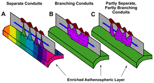
Lineaments
with central volcanoes tapping a layer underneath |
The
layer is also variably enriched, especially in
constituents of the EMII component such as 87Sr/ 86Sr.
The 206Pb/ 204Pb signature
of each lineament is much more consistent. Nevertheless,
206Pb/ 204Pb is lower along
the western portion of the chain. Thus lineaments
that form at the eastern end of the chain with
high 206Pb/ 204Pb are carried
by plate motion over mantle with lower 206Pb/ 204Pb,
which shows up in the post-erosional lava succession
(Figure 3). The general notion of a shallow enriched
asthenospheric layer is in accord with the perisphere
concept of Anderson
(1995). |
|
| 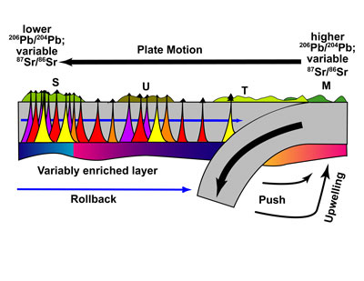
Schematic of possible mechanisms
of Samoan volcanism |
More
complicated geometries might exist. A mantle
plume active for at least the past 14 Ma could
now be centered beneath Vailulu`u. However,
placement of a deep plume (e.g., Courtillot
et al., 2003) right at the curving corner
of the Tonga Trench must be entirely fortuitous.
Alternatively, thermal-convective disturbances
triggered by trench rollback and the complex
geometry of subduction at the curving corner
of the trench may initiate diapir-like uprise
of mantle material beneath this part of the
Pacific Plate (Figure 3). |
Nevertheless,
regardless of the depth or mechanism of upwelling,
if the entire isotopic signal is contained within
an upwelling mass of mantle that penetrates
depleted mantle, a complicated form of zoning
would still need to be hypothesized in order
to account for distinctions in Pb isotopes between
shield and post-erosional lavas, and an equally
complicated model of sub-lithospheric dispersal
developed in order to explain the long distance
over which isotopically distinctive post-erosional
lavas have simultaneously erupted. |
|
| Tapping of an enriched
layer beneath the lithosphere, on the other hand, only
requires a mechanism for concentrating enriched mantle
at the base of the lithosphere. Perhaps the relatively
rigid lithosphere simply acts as a permeability barrier.
Small-degree partial melts of generally alkalic basaltic
character might then derive from a widespread, veined,
deeper mantle that is everywhere near its solidus. The
melt only needs to ascend buoyantly and concentrate in
a layer at the base of the lithosphere. |
Comment
Geochemists
now tend to ascribe the various isotopic end-members
in ocean-island basalts to materials that must once
have been at the Earth's surface. EMI and EMII thus
represent varieties of sediment, and HiMu some type
of hydrothermally altered ocean crust (Zindler
& Hart, 1986; Hofmann, 1997; Stracke
et al., 2003). A plume individually featuring
or combining these isotopic characteristics rising
from the core-mantle boundary thus represents material
that has cycled entirely down through the mantle,
and then up again. All these materials originally
were hydrous, the sediments in particular being feldspathic
and clay-rich. Even if shallow subduction processes
squeeze out most of the water (Dixon et al.,
2002), the sedimentary components at least are materials
that are both never denser than mantle peridotite
and which begin to melt at lower temperatures.
What
is easier to imagine? Do these materials actually
overcome their tendencies to be buoyant and begin
to melt, proceed then to the deepest levels of the
mantle, and then come all the way back up? Or upon
subduction do they simply never get all the way down?
Are they instead, in a complicated welter of ever-changing
marginal subduction zones like that in the modern
Philippine Sea, more usually cut off and abandoned
in the shallow mantle, and then caught in collisional
sutures? Over geological time, how much subducted
ocean crust and affiliated sediment by such means
comes to rest for many millions or billions of years
in the shallow upper mantle? On achieving ambient
mantle temperatures, would such materials then partially
melt and supply small, buoyant enriched melt fractions
to a layer beneath initially impermeable lithospheric
plates passing overhead? Could an ancient region of
such trapped or abandoned masses of ocean crust and
sediment today show up as a broad, shallow zone of
anomalous mantle and provide distinctive isotopic
characteristics to seamount and island provinces over
a broad area, such as much of Polynesia?
What
would distinguish this geophysically from a superplume?
Are the plates so rigid that they cannot deform either
internally or at their edges, in this way releasing
pent-up enriched melt accumulated at their base? Or
do they depend for this, and for the enriched material
itself, on the separate motive force of a deep mantle
plume? At Samoa, why should a plume fortuitously impinge
on the lithosphere precisely at the one place in the
Pacific Basin where shallow deformation forces acting
on the lithosphere are most concentrated, and where
everything else around is subsiding?
Finally,
if a shallow layered mantle source at Samoa is at
all plausible, it has to call into question whether
petrologically similar places such as Hawaii, Reunion,
Tahiti or the Azores result from any greatly dissimilar
process.
|
| References
-
Anderson, D.L., 1995. Lithosphere, asthenosphere, and perisphere. Rev. Geophys. 33: 125-149.
-
Atkinson, B. K., (Ed.), 1987. Fracture Mechanics of Rocks: San Diego, CA (Academic Press).
-
Barazangi, M., and Isacks, B., 1971. Lateral variation of seismic-wave attenuation in the upper mantle above the inclined earthquake zone of the Tonga Island arc: deep anomaly in the mantle. J. Geophys. Res., 76: 8493-8515.
-
Caldwell, J.G., Haxby, W.F., Karig, D.E., and Turcotte, D.L., 1976. On the applicability of a universal elastic trench profile. Earth Planet. Sci. Lett., 31: 239-246.
-
Chen, C.-Y., and Frey, F.A., 1983. Origin of Hawaiian tholeiite and alkalic basalt. Nature, 302: 785-789.
-
Courtillot, V., A. Davaillie, J. Besse, and J. Stock, 2003. Three distinct types of hotspots in the Earth's mantle, Earth planet. Sci. Lett., 205: 295-308.
-
Dixon, J.E., Leist, L., Langmuir, C., and Schilling, J.-G., 2002. Recycled dehydrated lithosphere observed in plume-influenced mid-ocean-ridge basalt. Nature 420: 385-389.
-
Farley, K.A., Natland, J.H., and Craig, H., 1992. Binary mixing of enriched and undegassed (primitive?) mantle components in lavas from Tutuila, American Samoa. Earth Planet. Sci. Lett., 111:183-199.
-
Feigenson, M.D., Hofmann, A.W., and Spera, F.J., 1983. Case studies on the origin of basalt, II. The transition from tholeiitic to alkalic volcanism on Kohala volcano, Hawaii. Cont. Min. Pet., 84: 390-405.
-
Hart, S.R., Staudigel, H., Blusztajn, J., Baker, E.T., Workman, R., Jackson, M., Hauri, E., Kurz, M., Sims, K., Fornari, D., Saal, A., and Lyons, S., 2000. Vailulu`u undersea volcano: the new Samoa, Geochem, Geophys. Geosyst., 1: 2000GC000108, 1-13.
-
Hedge, C., 1978. Strontium isotopes in basalts from the Pacific Ocean basin. Earth Planet. Sci. Lett., 38: 88-94.
-
Kear, D., and Wood, B.L., 1959. The geology and hydrology of Western Samoa. N. Zeal. Geol. Surv. Bull., 63.
-
Lawn, B.R., and Wilshaw, T.R., 1975. Fracture of Brittle Solids: New York (Cambridge University Press).
-
Millen, D.W., and Hamburger, M.W., 1998. Seismological evidence for tearing of the Pacific plate at the northern termination of the Tonga subduction zone. Geology, 26: 659-662.
-
Natland, J.H., 1980. The progression of volcanism in the Samoan linear volcanic chain. Am. J. Sci., 280A (Jackson Volume), 709-735.
-
Stearns, H.T., 1940. Four-phase volcanism in Hawaii (abs.), Geol. Soc. Am. Bull. 55: 1947-1948.
-
Stice, G.D., and McCoy, F.W., Jr., 1968. The geology of the Manu`a Islands, Samoa. Pac. Sci., 22: 426-457.
-
Sykes, L., Isacks, B., and Oliver, J., 1969. Spatial distribution of deep and shallow earthquakes of small magnitude in the Fiji-Tonga region. Seismol. Soc. Amer. Bull., 59:1093-1113.
last updated 26th April, 2003
|
|
|
