|
Yellowstone time-progressive volcanism results from time-progressive extension |
Gillian
R. Foulger
Dept.
Geological Sciences, Durham University, Durham
DH1 3LE, U.K.; g.r.foulger@durham.ac.uk
This webpage is a summary of: Foulger, G.R., R.L. Christiansen and D.L. Anderson, The Yellowstone ‘hot spot’ track results from migrating Basin Range extension, In: The Interdisciplinary Earth: A volume in honor of Don L. Anderson, Eds. Foulger, G.R., Lustrino, M., King, S.D., GSA Special Paper SPE514, American Geophysical Union Special Publication 71, pp 215–238, 2015, doi:10.1130/2015.2514(14).
Introduction
Whether the volcanism of the Columbia River Plateau, Eastern Snake River Plain, and Yellowstone is related to a mantle plume (the “Plume” hypothesis) or to plate-tectonic-related processes (the “Plate” hypothesis) is controversial. The strongest argument in favour of the plume model is the time-progressive trail of silicic volcanism that stretches from McDermitt caldera at the western end of the Eastern Snake River Plain (ESRP) to Yellowstone itself at the eastern end (Figure 1). The prediction of Morgan [1971] that the locus of volcanism in the ESRP-Yellowstone system has been fixed relative to that in the Hawaiian system was confirmed by measurements and even improved when correction was made for basin-range extension. The additional observation there of high-3He/4He ratios, commonly attributed to a core-mantle boundary source, has been viewed as additional confirmation.
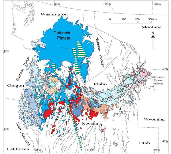
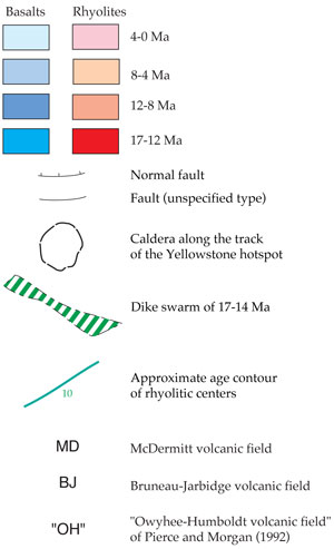
Figure 1: Map of the northwestern United States showing basin-range faults, and basalts and rhyolites of 17 Ma and younger. Approximate age contours of rhyolitic volcanic centers (~12, 10, 8, 6, 4, and 2 Ma) across the northeast-trending Eastern Snake River Plain are shown. A contemporaneous trend of oppositely propagating rhyolitic volcanism that trends northwest across central Oregon is indicated by similar contours. Locations of calderas are from Pierce & Morgan [1992] and Christiansen [2001] [from Christiansen et al., 2002].
Despite this, numerous seismological studies spanning nearly half a century essentially all agree that the seismic low-velocity anomaly beneath Yellowstone is confined to the shallow mantle (Figure 2). The repeatability of seismological results is poor for features smaller than ~ 100 km (Figure 3) [Pavlis et al., 2012]. However, one finding that is ubiquitous among all models is that the base of the low-velocity anomaly beneath Yellowstone is shallow, with estimates ranging from 200-1000 km [e.g., Burdick et al., 2012; Christiansen et al., 2002; Courtillot et al., 2003; Iyer et al., 1981; James et al., 2011; Montelli et al., 2006, 2004a, 2004b; Ritsema & Allen, 2003; Schmandt & Humphreys, 2010; Tian et al., 2009; Xue & Allen, 2010].
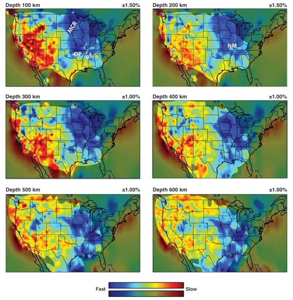
Figure 2 : Lateral variations in VP according to model MITP_USA_2013JAN at 100, 200, 300, 400, 500, and 600 km depth in the mantle beneath North America. Note that the 100- and 200-km depth slices are saturated at ±1.5% velocity anomaly, and the other depths at ±1%. MCR: Midcontinent Rift; OP: Ozark Plateau; RF: Reelfoot Rift; NM: New Madrid Seismic Zone. In the slice at 100 km depth, the three tongues of low velocity that trend NE under the W USA and underlie, from north to south, the ESRP-Y, St. George, and Valles volcanic zones, are particularly clear [from Burdick et al., 2014].
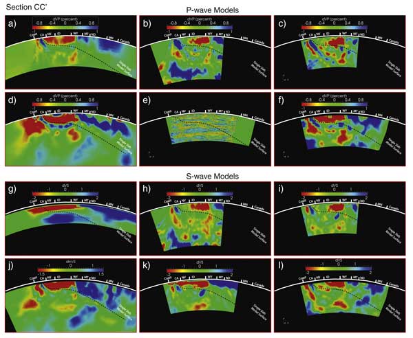
Figure 3 : Cross section through the western USA running from Cape Mendocino to the Canada–Minnesota border. Sections are viewed from the southeast and slice the same section of each volume. The white line on each section is Earth's surface with geographic boundaries marked by radial, white colored ticks. States are defined by standard two-character postal abbreviations. Tomography models all show high velocities as blue and low velocities as red with the scale shown on each section. The scattered wave image result (e) shows positive P-to-S conversion scattering potential in red and negative conversion as blue. VP tomography results are as follows: (a) MIT11, (b) NWUS11-P, (c) DNA09P, (d) SIG11, (f) UOP (e) PWMIG11. VS tomography results in the lower panel are (g) NA07, (h) NWUS11-S, (i) DNA09S, (j) TIA10, (k) DNA10, (l) UO10S. See Pavlis et al. [2012] for further details. Click here or on Figure for enlargement.
Problems with the Plume model
A shallow origin for ESRP-Yellowstone volcanism discredits the case for a mantle plume. The fundamental premise of the plume hypothesis is that deep origins, below the shallow, rapidly convecting layer, are required to explain relative fixity. The mantle plume hypothesis cannot explain relative fixity of volcanic loci fed from the shallow mantle, in particular in a dynamically active part of the mantle such as exists beneath the western USA. Furthermore, the high-3He/4He ratios commonly considered to clinch the case for a deep-mantle plume rests on the assumption that this geochemical signature derives from the core-mantle boundary. Clearly, this cannot be the case at the ESRP-Yellowstone if the source of volcanism is shallow (see also Missing Pb, High 3He/4He, Ancient Sulfides and Continent Formation).
At Yellowstone, Plume theory is thus in the curious quandry whereby what are considered to be two of the strongest indicators of a mantle plume from the core-mantle boundary are confirmed, but the source of volcanism is shown to a high degree of certainty to be shallow. Any claim that the source is the core-mantle boundary would have to rest on a “celestial teapot” argument, i.e. assuming a structure exists that is too small to be detected using existing technology. The problem with such arguments is, of course, that even if technology improves it is always possible to downward-adjust estimates of the size of the postulated plume conduit.
The Plate model
The “Plate” model postulates that anomalous volcanism occurs where the lithosphere extends, allowing pre-existing melt to escape to the surface. Melt is considered to be widespread in the shallow mantle in varying amounts. Where large volumes of magma erupt in an extending province, the signature of a fusible (low-melting-point) source is expected, e.g., remelted near-surface materials such as subducted oceanic lithosphere, metasomatized continental mantle lithosphere, or lower continental crust.
It is a common misconception that in the Plate model, all that is required to explain volcanism is the existence of melt in the mantle, and that surface volcanism is merely a map of where melt exists in the mantle. This is not the case. In the Plate model, the mantle is considered to be able to retain melt until such time as lithospheric extension permits it to rise to the surface. Volcanism is thus a consequence of lithospheric extension, and not solely a consequence of the existence of melt in the mantle.
In general, the percentage of partial melt in the mantle is likely to be small, though in extreme cases large melt reservoirs may accumulate and release to form flood-basalts [Silver et al., 2006]. This is required by the largest flood-basalt provinces because in those cases no plausible decompression-upwelling melting scenario can generate melt as quickly as it erupts. The Columbia River Basalts may result from such melt-reservoir-release in the extending back-arc basin environment that pertained in the region at ~ 17 Ma when they formed. At about this time, the Basin & Range Province of the western USA also began to form, in response to reorganization of the plate boundary on the west coast of the USA, now represented by the San Andreas fault zone.
If volcanism results from extension, then time-progressive volcanism is predicted to result from time-progressive extension. Basalt has erupted continuously along the entire length of the ESRP-Yellowstone zone since its formation [Christiansen & Yeats, 1992]. It is the rhyolitic caldera volcanoes that are time-progressive, and they are attributed to re-melting of the lower crust. It is thus predicted that crustal extension swept from west to east along the ESRP, permitting the lower crust to rise, decompress and partially melt, and that this process is currently ongoing at Yellowstone (Figure 4).
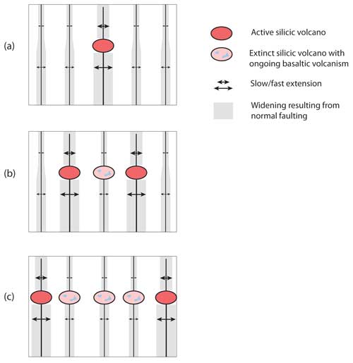
Figure 4 : Schematic figure illustrating a model whereby the time-progressive chain of rhyolitic calderas in the ESRP-Y zone (rhyolitic volcanism ongoing - red, rhyolitic volcanism extinct - pink) formed in response to the eastward migration of the axis of most intense basin-range extension. The complimentary ‘Newberry trend’ formed by westward migration. Time increases (a) - (c).
That this has indeed occurred is bourn out by observation. Anders [1994] shows that migration of silicic volcanism on the ESRP-Yellowstone zone has gone hand-in-hand with accelerated normal-fault motion on nearby large, range-bounding normal faults (Figure 5). Pierce & Morgan [2009] describe Cenozoic faulting south of the three youngest rhyolitic calderas of the ESRP-Yellowstone and also find that belts of fault activity migrated NE in conjunction with adjacent rhyolitic volcanism. These findings are supported by recent GPS surveying across the Basin & Range Province. That surveying shows that extension is not uniform across the entire 500-km-wide Province but is mostly concentrated in two zones of intense extension in the west and east [Thatcher et al., 1999].
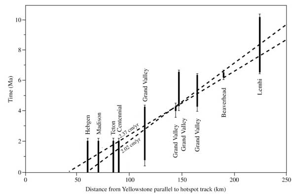
Figure 5 : Migration of high fault displacements on large range-bounding normal faults in the vicinity of the ESRP-Yellowstone zone [after Anders, 1994]. The rate of migration of high fault activity is 2.02 - 2.37 km/Ma, similar to the migration rate of large caldera-forming volcanism from 10 to 2 Ma.
The picture that emerges is one whereby extension in the Basin & Range Province has been dominated by two axes of enhanced extension that have migrated to the west and east (Figure 4). The northern end of the easterly-migrating axis is represented by the ESRP-Yellowstone zone, where extension has been dominantly “wet” (i.e. magmatic) and not dominantly “dry” (i.e. normal faulting) as occurs further south in the Basin & Range Province. The Plate model for Yellowstone proposes that the time-progressive rhyolitic volcanism followed migration of the locus of rapid extension, not vice versa.
Why does extension occur in a different mode along the ESRP-Yellowstone zone compared with the Basin & Range Province? There is a profound structural gradient at the latitude of the ESRP-Yellowstone zone. It lies at a major lithospheric boundary where thin basin-range lithosphere to the south is juxtaposed against the thick lithosphere of the Northern Rocky Mountains and Idaho batholith to the north. Across this transitionary zone, the rate of extension decreases abruptly over a distance of only 100 km. At such a structural discontinuity, the mode of crustal extension can change.
In this Plate model for the ESRP-Yellowstone system, the apparent fixity of the Yellowstone melt-extraction locus to that of the Hawaiian system results from both being quasi-stationary with respect to the Pacific-North American plate boundary itself. The position of each melt-extraction locus at a given time is related to the stress field in the interior of the plate in which it lies. Volcanism occurs at foci of extension, and these remain fixed relative to the plate boundaries if the latter are relatively stable.
A simpler model
Foulger et al. [2015] list 16 geological and geophysical observations that are either at odds with the Plume model or require special pleading. The Plate model for Yellowstone described here fits naturally with those observations. In the Plate model, the ESRP-Yellowstone system is viewed as an integral part of the complex and dynamically evolving western USA, and not as the product of an ad hoc, deus ex machina mantle plume that co-incidentally happened to arrive simultaneously with a radical tectonic reorganization that resulted from changes in the local plate boundary.
References
-
Burdick, S., R. D. van der Hilst, F. L. Vernon, et al. (2014), Model update January 2013: Upper mantle heterogeneity beneath North America from travel time tomography with global and USArray transportable array data, Seismol. Res. Lett., 85, 77-81.
-
Christiansen, R. L., and R. S. Yeats (1992), Post-Laramide geology of the U.S. Cordilleran region, in The Cordilleran orogen: Conterminous U.S., edited by B. C. Burchfiel, P. W. Lipman and M. L. Zoback, pp. 261-406, Geological Society of America, Boulder, Colorado.
-
-
Courtillot, V., A. Davaillie, J. Besse, and J. Stock (2003), Three distinct types of hotspots in the Earth's mantle, Earth planet. Sci. Lett., 205, 295-308.
-
Foulger, G.R., R.L. Christiansen and D.L. Anderson, The Yellowstone ‘hot spot’ track results from migrating Basin Range extension, In: The Interdisciplinary Earth: A volume in honor of Don L. Anderson, Eds. Foulger, G.R., Lustrino, M., King, S.D., GSA Special Paper SPE514, American Geophysical Union Special Publication 71, pp 215–238, 2015, doi:10.1130/2015.2514(14).
-
Iyer, H. M., J. R. Evans, G. Zandt, R. M. Stewart, J. M. Coakley, and J. N. Roloff (1981), A deep low-velocity body under the Yellowstone caldera, Wyoming: Delineation using teleseismic P-wave residuals and tectonic interpretation: Summary, Bull. Geol. Soc. Am., 92, 792-798.
-
James, D. E., M. J. Fouch, R. W. Carlson, and J. B. Roth (2011), Slab fragmentation, edge flow and the origin of the Yellowstone hotspot track, Earth planet. Sci. Lett., 311, 124-135.
-
Montelli, R., G. Nolet, F. Dahlen, and G. Masters (2006), A catalogue of deep mantle plumes: new results from finite-frequency tomography, Geochem. Geophys. Geosys., 7(Q11007), 10.1029/2006GC001248.
-
Montelli, R., G. Nolet, G. Masters, F. Dahlen, and S.-H. Hung (2004a), Global P and PP traveltime tomography: rays versus waves, Geophys. J. Int., 158, 637–654.
-
Montelli, R., G. Nolet, F. A. Dahlen, G. Masters, R. E. Engdahl, and S.-H. Hung (2004b), Finite frequency tomography reveals a variety of plumes in the mantle, Science, 303, 338-343.
-
-
Pavlis, G. L., K. Sigloch, S. Burdick, M. J. Fouch, and F. L. Vernon (2012), Unraveling the geometry of the Farallon plate: Synthesis of three-dimensional imaging results from USArray, Tectonophysics, 532-535, 82-102.
-
Pierce, K. L., and L. A. Morgan (1992), The track of the Yellowstone hotspot: Volcanism, faulting, and uplift, in Regional geology of eastern Idaho and western Wyoming, edited by P. K. Link, M. A. Kuntz and L. B. Platt, pp. 1–53.
-
Pierce, K. L., and L. A. Morgan (2009), Is the track of the Yellowstone hotspot driven by a deep mantle plume? – Review of volcanism, faulting, and uplift in light of new data, J. Volc. Geotherm. Res., 188, 1-25.
-
Ritsema, J., and R. M. Allen (2003), The elusive mantle plume, Earth planet. Sci. Lett., 207, 1-12.
-
Schmandt, B., and E. Humphreys (2010), Complex subduction and small-scale convection revealed by body-wave tomography of the western United States upper mantle, Earth planet. Sci. Lett., 297, 435-445.
-
Silver, P. G., M. D. Behn, K. Kelley, M. Schmitz, and B. Savage (2006), Understanding cratonic flood basalts, Earth planet. Sci. Lett., 245, 190-201.
-
Thatcher, W., G. R. Foulger, B. R. Julian, J. Svarc, E. Quilty, and G. W. Bawden (1999), Present-day deformation across the Basin and Range Province, Western United States, Science, 283, 1714-1718.
-
Tian, Y., K. Sigloch, and G. Nolet (2009), Multiple-frequency SH-wave tomography of the western US upper mantle, Geophys. J. Int., 178, 1384-1402.
-
Xue, M., and R. M. Allen (2010), Mantle structure beneath the western United States and its implications for convection processes, J. Geophys. Res., 115(B07303), 10.1029/2008JB006079.
last updated 26th
November, 2015 |
